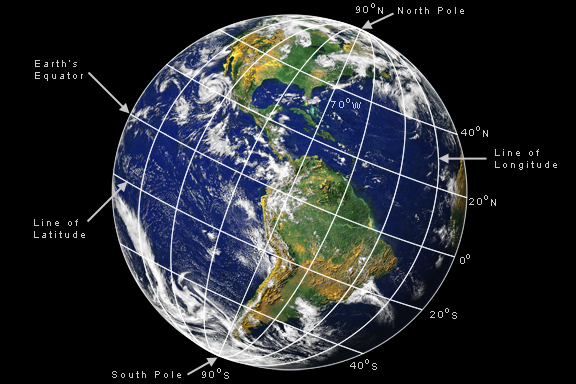
To locate an object in the sky, we have to know where it is. We do this with a set of celestial coordinates. These give the x and y coordinate location on a map of the celestial sphere. Longitude and Latitude on Earth On the Earth, we use a coordinate system of longitude and latitude to specify locations on a map.
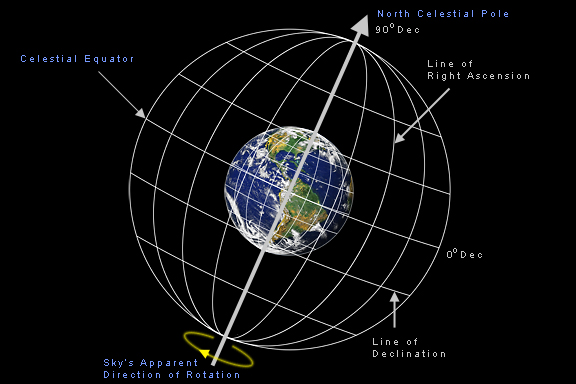
Longitude and latitude are an imaginary set of lines drawn on the Earth. Lines of longitude run north-south and converge at the poles of the Earth. They give location in the east-west direction. Lines of latitude run parallel to the equator of the Earth. They give location in the north-south direction. The north pole of the Earth is at 90 degrees north latitude, and the equator is 0 degrees latitude. Zero degrees longitude is called the prime meridian, and passes through Greenwich, England. Any location on the Earth can be specified by giving its coordinates in this grid. For example, Philadelphia is located at approximately 40 degrees north latitude, and 75 degrees west longitude. This means Philadelphia is 75 degrees west of Greenwich, and 40 degrees north of the equator. Right Ascension and Declination in the Sky Like locations on the Earth, we can also specify the location of any object in the sky with a coordinate grid. We simply extend the lines of longitude and latitude out into space and project them on the sky, but we call them lines of "right ascension" and "declination", respectively. They are abbreviated as RA and Dec. They give us the object's celestial coordinates on the celestial sphere. The celestial sphere is the apparent surface of the imaginary sphere on which celestial bodies appear to be located.
Lines of right ascension in the sky correspond to lines of longitude on the Earth. They run north-south and go through the north and south celestial poles. Right ascension in the sky is divided into 24 hours. The prime meridian in the sky, designated as 0 hours right ascension, is where the Sun crosses the celestial equator in the northern spring at the Vernal Equinox, a location called the First Point of Aries. Equinox means equal day and night. Right ascension is divided into units of hours, minutes and seconds of time. Hours of right ascension increase as you move eastward in the sky from the First Point of Aries. Lines of declination correspond to lines of latitude on the Earth. They run east-west and are parallel to the celestial equator. The north celestial pole has a declination of 90 degrees, and the celestial equator has a declination of 0 degrees. Declination is divided into units of degrees, minutes and seconds of arc. For example, Sirius, the brightest star in the night sky, is located at a right ascension of 06 hours 45 minutes and 34 seconds of time east of the vernal equinox, and a declination of -16 degrees, 43 minutes 54 seconds of arc south of the celestial equator. There are a couple of differences between lines of latitude and longitude on the Earth and lines of right ascension and declination in space. One is that right ascension is divided into hours instead of degrees. The other is that lines of latitude and longitude rotate with the Earth. Lines of right ascension and declination stay fixed in space, as the Earth rotates at the center of the celestial sphere.
* Earth image by Reto Stockli, Alan Nelson, Fritz Hasler NASA Visible Earth. Illustration composite and design by Jerry Lodriguss. |
|||||||
|
Back | Up | Next |